
Somewhere beneath the ocean’s surface, in places satellites have never been able to see clearly, scientists just found a staggering amount of life. Researchers working with a network of robotic ocean floats have calculated that the world’s phytoplankton, the microscopic organisms that quietly power much of Earth’s climate system, add up to a biomass roughly equivalent to 250 million elephants beneath the ocean’s surface.
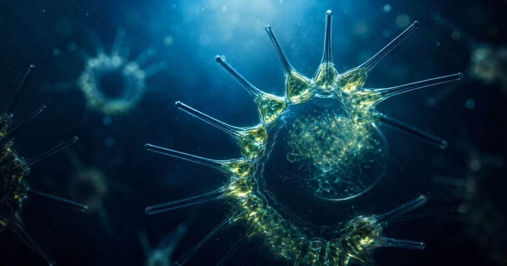
The discovery didn’t come from a single robot or a lucky expedition. It came from a global network of Biogeochemical-Argo (BGC-Argo) floats that complement satellite observations by measuring what satellites simply cannot reach.
And the implications go well beyond a jaw-dropping headline; this data is reshaping how climate scientists understand the ocean’s role in the global carbon cycle.
What Did the Canadian Robots Actually Discover?
Led by researchers connected to Dalhousie University, the study set out to answer a deceptively simple question: how much phytoplankton actually lives in the ocean, including the parts we can’t see from space?
After extensive quality control, the team worked with 99,341 bio-optical profiles collected from 903 BGC-Argo floats deployed over the past decade. That’s not a snapshot; it’s a decade-deep, ocean-wide dataset.
The resulting number is enormous. Global phytoplankton biomass came out to roughly 314 teragrams, or about 346 million tons, a figure researchers compared to the weight of 250 million elephants to make the scale tangible.
It’s worth noting this isn’t a perfectly exact figure; the researchers themselves point out the number may not be entirely precise, but it gives scientists a critical benchmark for tracking how ocean phytoplankton changes over time.
That benchmark is really the headline here, not the elephant comparison, but the fact that we now have a far more reliable starting point than we did before. What Did the Canadian Robots Actually Discover?
How BGC-Argo Floats Work (The Robotics Behind the Discovery)
This is the part most coverage of the story glosses over, and it’s arguably the most interesting piece: the technology that made this discovery possible in the first place.
What Is a BGC-Argo Float?
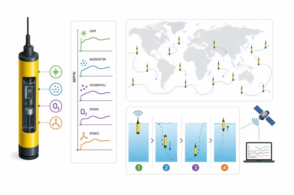
A BGC-Argo float is a free-drifting, autonomous ocean robot. Unlike a research vessel or a fixed sensor buoy, these floats aren’t anchored, and they aren’t remotely piloted. Each one is released into the ocean, where it drifts with the currents and periodically dives and resurfaces on its own, following a pre-programmed cycle.
A typical float might spend days below the surface before rising back up to transmit its data via satellite, then sink again to repeat the process. Multiply that by 903 floats scattered across every major ocean basin, and you get a genuinely global, continuously updating sensor network, something no single ship or satellite pass could replicate.
The Sensors Onboard: Backscatter, Chlorophyll Fluorescence, and Biogeochemical Sensors
What makes these floats useful for phytoplankton research specifically is the instrumentation packed into each unit. As the float rises and descends, it logs a vertical profile of the water column using a handful of key measurements:
- Chlorophyll fluorescence: chlorophyll is the pigment phytoplankton use for photosynthesis, and measuring how it fluoresces under light gives researchers a proxy for how much phytoplankton is present at a given depth.
- Particulate backscattering (bbp) measures how much light scatters off suspended particles in the water, which correlates with the concentration of organic material, including phytoplankton cells.
- Additional biogeochemical sensors, depending on the float, can include oxygen, nitrate, and pH sensors, which help researchers understand the surrounding conditions in which phytoplankton are growing.
How These Autonomous Floats Navigate and Profile the Ocean
There’s no engine driving these floats toward a destination. Instead, each one adjusts its own buoyancy, typically by changing the volume of an internal bladder to sink to a target depth, often around 1,000 to 2,000 meters, before rising back toward the surface on a set schedule.
As it ascends, it continuously records data through the water column, building a vertical “profile” from deep water up to the surface. Once at the surface, it transmits its readings to satellites and begins its next cycle.
It’s a good reminder that behind a headline-grabbing discovery like this is a lot of unglamorous engineering, the same kind of problem-solving covered in guides on how to build a robot meant to operate reliably with no one around to fix it.
Why Satellites Miss This: Robots vs. Satellite Monitoring
For decades, satellite ocean color imagery has been the primary way scientists have tracked phytoplankton at a global scale. It’s a genuinely useful tool, but it has a blind spot that BGC-Argo floats were specifically built to address.
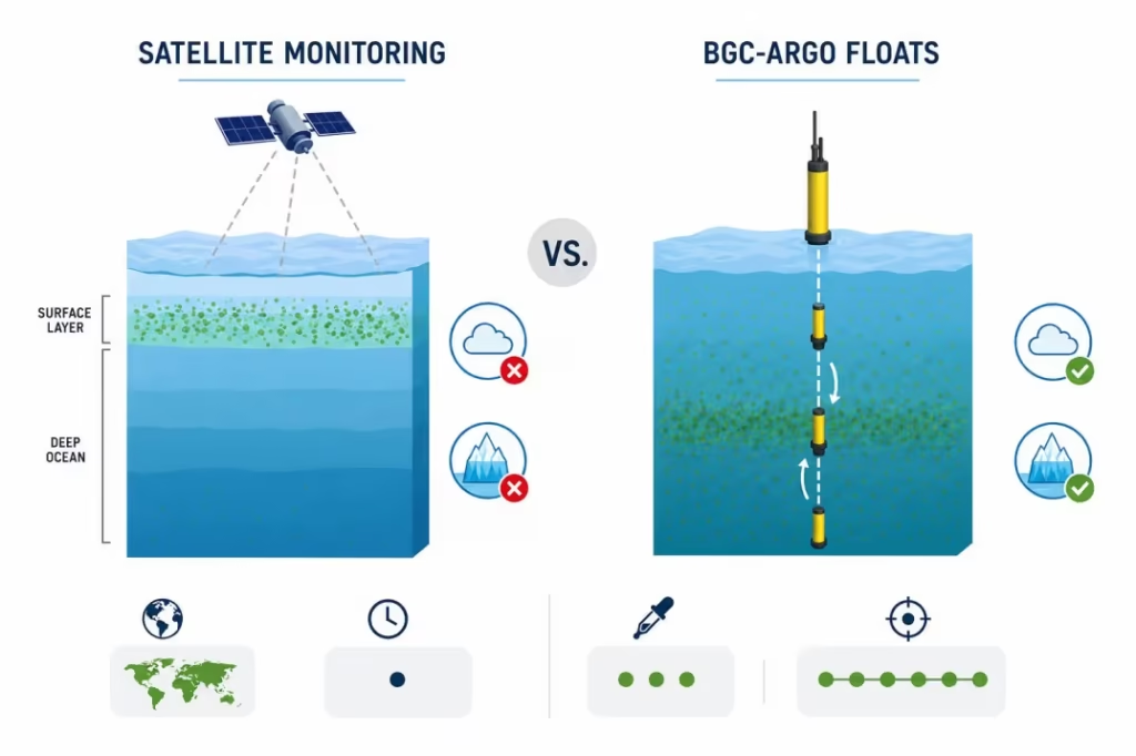
Ocean color satellites work by measuring the color of light reflected off the ocean’s surface. Chlorophyll changes how that light looks, so scientists can estimate surface phytoplankton concentrations just by analyzing satellite imagery.
The problem is right there in the description: it’s a surface measurement. Satellites can only see a thin top layer of the ocean, typically the first few tens of meters. Anything growing deeper simply doesn’t show up.
That’s a bigger gap than it sounds. A significant amount of phytoplankton grows at what oceanographers call the “deep chlorophyll maximum,” a layer well below the surface where light is dim but nutrients are more plentiful.
Satellites essentially miss this layer entirely, which means surface-only data has been underrepresenting how much phytoplankton actually exists in the ocean.
Satellites run into a second problem, too: they need a clear line of sight. Cloud cover, sea ice, and storm-churned water all interfere with the readings, leaving gaps in coverage across huge parts of the ocean, including polar regions, where sea ice is present for much of the year.
BGC-Argo floats sidestep both problems. Because they physically travel down through the water column, they capture data at the deep chlorophyll maximum and every depth in between, not just the surface. And because they aren’t relying on light reflecting to a satellite, they can keep collecting data under sea ice, through storms, and beneath persistent cloud cover.
| Satellite Monitoring | BGC-Argo Floats | |
|---|---|---|
| Coverage depth | Surface only (top ~tens of meters) | Full water column, including deep chlorophyll maximum |
| Works under cloud cover/sea ice | No | Yes |
| Spatial coverage | Very broad, near-instant | Narrower per float, but continuous over time |
| Data type | Indirect (light reflectance) | Direct in-situ sensor readings |
| Best used for | Broad surface trends, rapid snapshots | Precise, depth-resolved measurements |
Why Phytoplankton Matter for the Planet
It’s easy to skim past phytoplankton as an afterthought; they’re microscopic, invisible to the naked eye, and easy to dismiss as background noise in a much bigger ocean story. In reality, they’re one of the most consequential life forms on the planet.
Phytoplankton are single-celled organisms that photosynthesize, much like plants do on land. They float near the ocean’s surface and in that deep chlorophyll layer discussed earlier, using sunlight and dissolved carbon dioxide to grow. That process alone makes them essential to life on Earth in ways most people never think about.
They produce roughly half the oxygen we breathe. Trees and forests get most of the credit for oxygen production, but phytoplankton are responsible for an estimated half of the oxygen entering Earth’s atmosphere. Every second breath a person takes can be traced, in part, back to these microscopic ocean organisms.
They form the base of the marine food web. Nearly every other form of ocean life depends on phytoplankton, directly or indirectly. Zooplankton graze on them, small fish eat the zooplankton, larger fish eat the smaller ones, and the chain continues up through seabirds, marine mammals, and the fisheries that feed billions of people.
A shift in phytoplankton abundance doesn’t stay contained at the bottom of that chain; it ripples upward through the entire ecosystem.
They pull carbon dioxide out of the atmosphere. As phytoplankton photosynthesize, they absorb CO2 from the surrounding water, which in turn draws more CO2 out of the atmosphere and into the ocean.
Some of that carbon eventually sinks to the deep ocean as phytoplankton die or get consumed, locking it away for long periods in a process scientists call the biological carbon pump. It’s one of the planet’s largest natural systems for offsetting human carbon emissions.
What This Discovery Means for Climate Science
A Missing Variable in Carbon Budget Models
Climate scientists build models to track how carbon moves through the planet’s systems: how much humans emit, how much land ecosystems absorb, how much the ocean absorbs, and how the leftover balance affects atmospheric CO2 levels over time.
The ocean’s contribution to that budget depends heavily on phytoplankton, since they’re the organisms doing most of the carbon drawdown at sea.
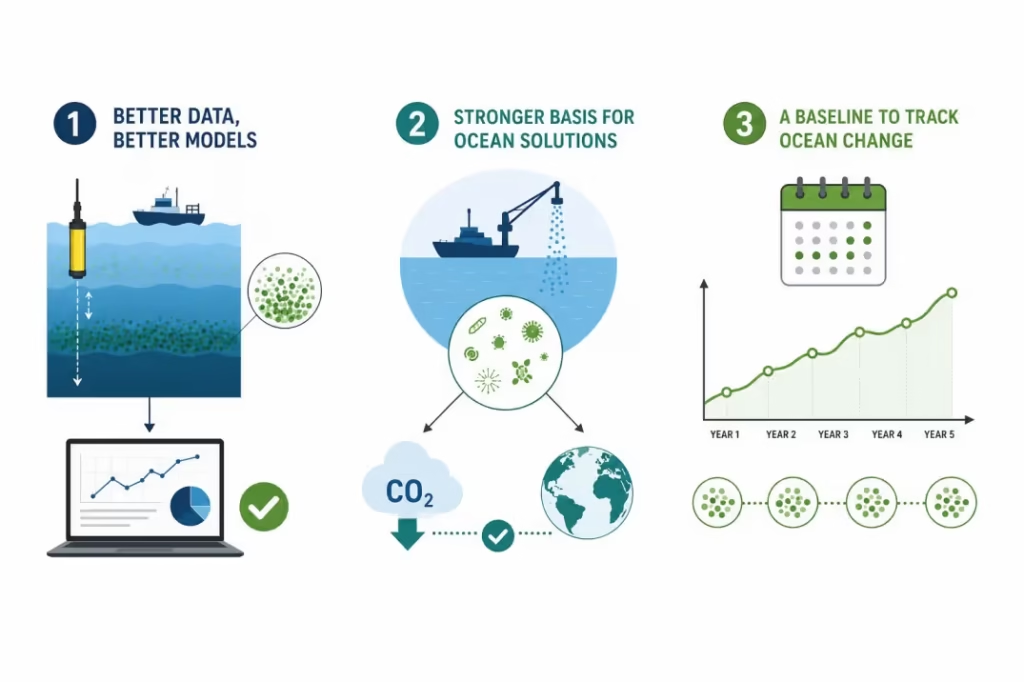
The problem is that these models have historically leaned on satellite-derived surface estimates, the same estimates now shown to miss a substantial share of subsurface phytoplankton biomass. If the input number was systematically too low, then any model built on top of it inherits that gap.
A more complete, depth-resolved biomass figure gives climate scientists a more accurate input to work with, which matters because carbon budget models are only as reliable as the data feeding into them. Correcting an undercounted variable like this doesn’t just add a footnote to existing research; it gives future models a better foundation to build on.
Implications for Geoengineering Proposals
Phytoplankton biomass also matters for a more contentious area of climate science: geoengineering. Some proposed interventions, like ocean iron fertilization, which aims to stimulate phytoplankton growth to absorb more atmospheric CO2, depend on understanding how much phytoplankton already exists and how the population naturally varies across seasons and regions.
Researchers involved in this kind of work have pointed out that any proposed intervention needs to be judged against a realistic, depth-resolved picture of existing phytoplankton stocks, not a surface-only approximation.
Without that baseline, it’s difficult to know whether a geoengineering approach is meaningfully changing ocean biomass or simply operating within the range of natural variability. This new dataset gives that conversation a far sturdier foundation than existed before.
Better Baselines for Tracking Ocean Health Over Time
Beyond the immediate modeling and policy implications, this discovery gives climate scientists something arguably more valuable in the long run: a proper benchmark. A single measurement, however large, is really only the starting point.
What matters going forward is being able to compare future readings against this baseline to see how phytoplankton populations shift as ocean temperatures rise, currents change, and ice coverage shrinks in polar regions.
Because the BGC-Argo network is ongoing rather than a one-time survey, researchers can keep collecting comparable data year after year. That continuity is what turns a single striking statistic into a genuine climate science tool, the ability to detect trends, not just take a snapshot.
Broader Implications, Fisheries, Food Security, and Ocean Health
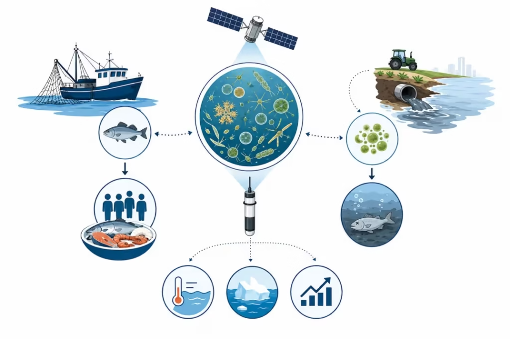
Climate models and geoengineering debates tend to dominate the conversation around discoveries like this, but the ripple effects reach much further into everyday life than most people realize.
Fisheries and food security. Because phytoplankton sit at the base of the marine food web, changes in their abundance or distribution eventually show up in fish populations.
Fisheries scientists already use phytoplankton data to help forecast fish stock health in certain regions, and a more accurate global picture of biomass, including the parts satellites miss, gives that forecasting work a stronger foundation.
For the billions of people who rely on seafood as a primary protein source, that’s not an abstract scientific detail; it’s a direct link to food supply stability.
Coastal ecosystem management. Phytoplankton populations don’t stay perfectly balanced everywhere. In some coastal areas, excess nutrients from agricultural runoff and other sources can trigger overly dense phytoplankton blooms, Interestingly, some of the same precision agricultural robotics being developed to apply fertilizer more accurately are also being explored as a way to cut down on this kind of runoff at the source.
Better global monitoring, including subsurface data from BGC-Argo floats, helps researchers understand where these bloom conditions are developing and how they connect to broader ocean health trends.
A more complete picture of ocean change. Ultimately, this discovery reinforces something oceanographers have suspected for a while: the ocean’s surface only tells part of the story.
As ocean temperatures shift and ice coverage changes in polar regions, having reliable subsurface data becomes essential for understanding how marine ecosystems are actually responding, not just how they appear from above.
What’s Next for Ocean Robotics Research
This discovery isn’t really an endpoint; it’s closer to a proof of concept for where ocean monitoring is headed.
Expanding the BGC-Argo network. The 903 floats used in this study already represent a decade of steady deployment. Still, researchers are continuing to add more floats to the network, particularly in undersampled regions like the polar seas and remote areas of the Southern Ocean where data has historically been sparse. More floats mean finer-grained coverage and faster detection of changes as they happen, rather than years later.
Combining float and satellite data more closely. Rather than treating satellites and BGC-Argo floats as separate tools, researchers are increasingly working to integrate the two, using floats to calibrate and correct satellite estimates so that broad surface-level satellite coverage can be trusted with more confidence, even in the areas floats haven’t directly measured. That combination plays to the strengths of each system: satellites for breadth, floats for depth and precision.
A bigger role for autonomous ocean robotics. This study is also part of a larger trend that extends well beyond phytoplankton research. Autonomous underwater vehicles and free-drifting sensor networks are It’s part of a wider pattern, autonomous systems are already reshaping fields as different as robotics in healthcare and ocean science, and marine research is simply one of the latest to benefit.
As sensor technology gets smaller, cheaper, and more capable, networks like BGC-Argo will likely keep expanding and keep uncovering findings that reshape how climate scientists understand the ocean.
1. What did the Canadian robots actually discover about ocean phytoplankton?
Researchers connected to Dalhousie University used data from a global network of Biogeochemical-Argo (BGC-Argo) floats to calculate that Earth’s total phytoplankton biomass is roughly 343 million tonnes, an amount often compared to the weight of 250 million elephants. Critically, at least half of that biomass had never been directly observed by satellites before.
2. What is a BGC-Argo float?
A BGC-Argo float is a free-drifting, autonomous ocean robot that dives and resurfaces on its own, measuring biogeochemical properties like chlorophyll fluorescence and particulate backscattering as it moves through the water column. Unlike satellites, it can record data from deep below the ocean’s surface, not just the top layer.
3. Why can’t satellites detect all the ocean’s phytoplankton?
Ocean color satellites can only read light reflected from a thin surface layer of the ocean. A large share of phytoplankton lives deeper, in a zone known as the deep chlorophyll maximum, which satellites simply can’t see. Clouds, sea ice, and storms create further gaps in satellite coverage that BGC-Argo floats aren’t affected by.
4. How many BGC-Argo floats were used in this study?
The research drew on roughly 100,000 water-column profiles collected from hundreds of BGC-Argo floats deployed globally over the past decade, giving scientists one of the most comprehensive phytoplankton datasets ever assembled.
5. Why does phytoplankton biomass matter for climate science?
Phytoplankton play a major role in absorbing atmospheric carbon dioxide and producing roughly half of the oxygen we breathe. Climate scientists rely on accurate biomass estimates to build carbon budget models, and this discovery corrects a longstanding gap in data that satellite-only estimates had been missing.
6. Is 250 million elephants an exact comparison?
No, it’s a scale comparison meant to make an otherwise abstract number (roughly 343 million tonnes) easier to visualize. Researchers themselves note the figure isn’t perfectly exact, but it serves as a useful benchmark for tracking future changes in ocean phytoplankton.
7. What’s next for BGC-Argo and ocean robotics research?
Scientists are continuing to expand the BGC-Argo network, particularly in undersampled regions like the polar seas, while working to combine float data more closely with satellite observations. This is part of a broader trend toward using autonomous ocean robotics for long-term climate and marine ecosystem monitoring.